
8 Oct 2026
Drought and an ailing aquifer were major topics of conversation when NASA scientists visited with farmers in the Texas High Plains.
For many longtime cotton farmers in the Texas High Plains, the 2026 drought sparked flashbacks to catastrophic harvests of the past. Miserably dry seasons forced farmers in America's largest cotton-producing region to abandon massive portions of their dryland crop, including 72 percent in 2022 and 66 percent in 2011.
But in some ways, farmers felt the drought in 2026 entered new territory. "This is the first year that we've had cotton completely die," said Lacy Cotter-Vardeman, a farmer based in Lubbock County whose family has worked the land there for several generations. "I was just talking to our insurance people, and they said they'd never seen this before," she said, adding that roughly 90 percent of her dryland cotton was dead.
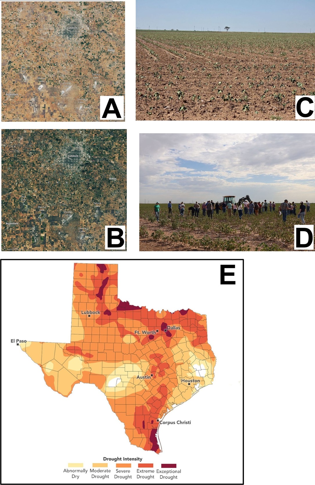
Satellite images highlight the scale of the problem in Lubbock and adjacent counties. Brown, parched crops and vacant plots dominated the landscape on September 9, 2026, when the OLI (Operational Land Imager) on Landsat 8 captured the image above (right). In contrast, much greener landscapes prevailed on September 22, 2025 (left), when the sensor captured an image of the same area during a more typical year with a relatively healthy harvest.
Subtler signs of the drought are also visible. With groundwater growing scarce in the High Plains aquifer, many farmers in the region have started irrigating just one-half or one-third of their center-pivot fields, explained Tillery Timmons-Sims, an agricultural conservationist who owns land in Brownfield, Texas, and used to grow cotton. In the imagery, these appear as green semicircles and quarter circles.
Note also the many shallow water features known as playa lakes—sometimes called mud holes, buffalo wallows, and lagoons—scattered throughout the image. Some, like Double Lakes and Mound Lake, are fairly large, but most of the more than 19,300 playa lakes in the Texas High Plains are quite small, less than 30 acres.
Many of these ephemeral lakes were dry in September 2026, unlike the previous year. Playa lakes are critical in this water-stressed region because the clay-lined features, if active, collect rainfall and provide pathways for water to seep underground and recharge the aquifer below, the region's primary source of irrigation water. However, about 80 percent are modified by tilling or buried with sediment, and many no longer function that way.
Farmers in this region operate along the eastern margin of the aquifer, which has declined sharply in recent decades. According to U.S. Geological Survey data, the water table across much of Lubbock County has dropped by between 25 and 100 feet since 1950, around when people began drawing large volumes of water from the aquifer to irrigate. Losses have been even more extreme (150 feet or more) in counties to the north, including Parmer, Castro, Swisher, and Briscoe.
The aquifer's long-term decline, combined with the 2026 drought, left many wells "pumping air" this summer for some of the farmers Timmons-Sims knows. "We simply don’t have groundwater to fall back on anymore," she said. Many farmers she knows thought that water might run out during the next generation; instead, it's "happening now," she said. For Cotter-Vardeman, the problem couldn't be more tangible. Many of her irrigation wells stopped working in August.
Rains in September and October, aided by a strong El Niño in the Pacific, are bringing needed moisture to the region, but they haven’t been enough, according to analysis from the U.S. Drought Monitor. "Despite the recent heavy rainfall in western Texas, it will take more than 7 additional inches of rain over a three-month period to 'end' the current drought, with much more rain needed in Oklahoma and central and eastern Texas," said Jonathan Case, a meteorologist at NASA’s Marshall Space Flight Center and one of the Drought Monitor’s authors.
The deteriorating aquifer is one of the reasons Timmons-Sims stopped farming in 2007. She now spends most of her time searching for ways to keep farms in business, such as converting irrigated croplands to grasslands to earn water credits, developing alternative energy projects, adopting water-efficient techniques, and working with conservation organizations to plan for the long term.
Through that work, the Sandhills Area Research Association, a conservation organization she helps run, partnered with NASA Acres, a research consortium that connects farmers with NASA science to address agricultural challenges.
In August, a NASA Acres Space for Agriculture listening tour brought NASA officials to Cotter-Vardeman's farm in Slaton, a vineyard in Meadow, and parched cotton fields in Kress (below). At each stop, the conversation returned to water: how to preserve the ailing aquifer, and how farmers could manage their land in ways that would help restore playa lakes and return billions of gallons of water to the aquifer.
The playa lakes around Lubbock were among the first scientific topics researchers studied after Landsat 1 launched in 1972. One early analysis by a Texas Tech geoscientist highlighted the Double Lakes playa (shown above), estimating that monitoring lakes from space would cost just a fraction of what ground surveys would.
More recently, a team of Texas Tech University researchers used a deep learning framework to identify and track changes affecting thousands of playa lakes over three decades. Their results, published in September 2026, showed that since 1995, playa lakes declined significantly in 15 of the 45 counties analyzed, highlighting the water challenges facing farmers like Cotter-Vardeman, a member of the NASA Acres Farm Innovation Ambassador Team (FIAT).
In Texas, Timmons-Sims and FIAT are working to connect farmers and NASA scientists, making it easier for farmers to use NASA data to decide what and when to plant, how to use cover crops and irrigation, and how to manage sediment and playa lakes. "We're simply running out of time and water," Timmons-Sims said. "Farmers need information, innovation, optimization, and solutions—and they need it now."
[Image]
(A) 9 Sep 2026
(B) 22 Sep 2025
(C) Rows of spindly, wilted cotton photographed in one of Cotter-Vardeman's fields in Slaton, Texas, appear stressed and near death on August 14, 2026.
(D) Farmers and NASA scientists inspect wilted cotton in Kress, Texas, during a NASA Acres Space for Agriculture listening tour on August 25, 2026.
(E) Drought remained severe across many parts of the Texas High Plains in October 2026 despite some rain falling in recent weeks. The data depicted in the map are produced by the U.S. Drought Monitor, a partnership between the National Drought Mitigation Center at the University of Nebraska-Lincoln, the U.S. Department of Agriculture (USDA), the National Oceanic and Atmospheric Administration, and NASA.